If you were to close your eyes and picture a map of the world, chances are you would imagine a conventional image: North America (including Greenland) and Europe at the top, Africa somewhere in the middle, and South America, Australia, and Antarctica at the bottom. But it does not have to be so, and it was not always so.
It’s not that our planet underwent change—it did, of course, but long before maps. Our conventions as map readers and makers have converged over time to a north-up default. What happens when that convention is challenged? Robert Simmon, a cartographer who previously developed maps for Planet Labs and NASA Earth Observatory, designed a map to address that question.
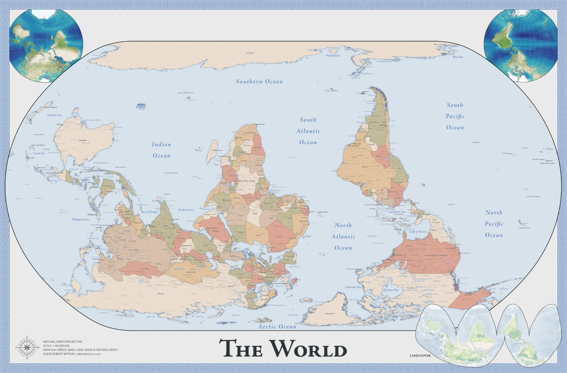
Simmon’s map includes countries, major lakes, oceans, gulfs, seas, roads, and cities. It also features inset maps depicting Earth’s biosphere, global land cover, and bathymetry. All of these are familiar to most map readers. Yet the map may seem disorienting to many. Simmon’s map is geographically correct, yet purposely—and literally—turns convention on its head. What was once familiar becomes alien, challenging readers to look at Earth anew. It also encourages us to think more deeply about such conventions: Why is north almost always at the top of maps? And must it always be that way? Simmon’s map reminds us that it doesn’t have to be.
Simmon is not the first to create a south-up map. Others have made these maps to challenge conventions and norms. And it was only rather recently that north-up maps became so commonplace. Centuries ago, cartographers drew maps with the top being south, east, or other orientations. These alternatives reflected the limited tools, knowledge, and practices of the time. The basic idea behind a compass (which most today recognize as a device that points north) was known to the Han and Tang dynasties of China more than 2,000 years ago. Early Chinese navigators used magnetized devices as a compass, but for them south was the dominant position from which bearings were derived.
Deciding to put south, or north, at the top of maps is a decision of consequence. Psychologically, we tend to view things nearer the top as ‘good’ and those lower as ‘bad.’ This can influence our interpretation of maps at both global and local scales. Still, the prominence of north-up maps did not arrive deliberately to elevate the status of some areas or their rulers. It is in part a consequence of the work of Ptolemey, who first labeled his maps with calculated lines of latitude and longitude. This made it easy for others to copy, extend, and derive new maps. Each map drawn in this way would adopt Ptolemy’s orientation.
Regardless of the reasons for a given orientation and the implications that follow, Simmon’s map reminds us to challenge tradition and consider its influence. As both a map and a philosophical prompt, this example hits the mark beautifully.
About This Map
- Title
- The World, South Up
- Creator
- Robert Simmon
- Data Sources
-
- Natural Earth, GEBCO
- NASA/USGS MODIS Land Cover Classification
- NOAA VIIRS NDVI
- NOAA VIIRS Ocean Color
This map was contributed through the Maps.com submission program. If you’d like your map to be featured, submit it for consideration.
- Tags