On March 11, 2011, a magnitude 9.0 earthquake struck off the coast of Japan. The intense quake, and the tsunami it triggered, caused extensive damage across the country, including at the Fukushima Daichii nuclear power plant. Critical safety systems at the plant were affected, leading to a partial nuclear meltdown. As a result, radioactive contaminants were released into the surrounding area. More than 100,000 people within 20 kilometers of the plant evacuated to limit exposure. Many have still not returned.
This animated map from cartographer Jack Scrivani tracks monthly radiation exposure throughout Japan. It uses crowdsourced measurements collected by Safecast from April 2011 to December 2016.
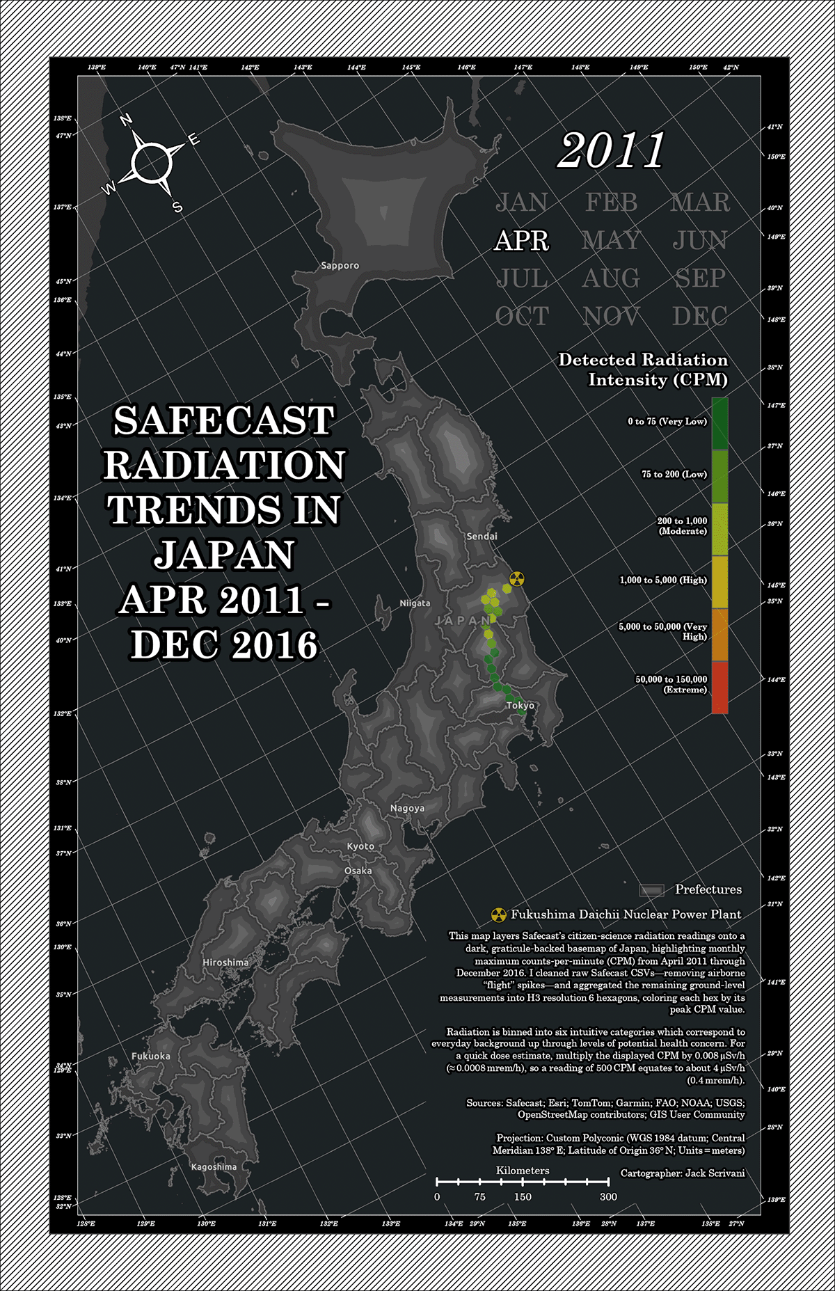
The map uses hexbins to show the maximum recorded counts per minute (CPM) over time. As a measure of radiation intensity, higher CPM values indicate more exposure to radiation. While the green-to-red color ramp isn’t color-blind safe, it highlights areas with greater exposure to radiation. A nuclear symbol marks the location of the nuclear plant in the Fukushima prefecture.
Beginning in 2011, the map reveals higher radiation levels in the areas surrounding the plant. But many places with higher readings are beyond the evacuation zone. Over time, you can see how the CPM value fluctuates and how proximity to the plant affects exposure. As the radiation decays and decontamination programs take effect, the levels begin to subside.
The map does not reflect measurements in the same places every month, and some areas are excluded altogether. Scrivani notes this is an artifact of the crowdsourced data. Measurements are most common in areas with more people, so populated areas and roadways are more represented. Less urbanized areas may have few or no measurements in the dataset.
The crowdsourced data has some limitations, but the map still tells a compelling story. While it’s not surprising that radiation levels were higher near the plant, the extent of the contamination is. The map reminds us how places and ecosystems are connected, even when they’re separated by long distances.
More to Explore
- Discover a crowdsourced map of air quality in Kigali, Rwanda.
- Visualize summer rain and heat patterns in Japan.
- Read a detailed explanation and timeline of the Fukushima Daiichi accident.
About This Map
- Title
- Safecast Radiation Trends in Japan April 2011 – December 2016
- Creator
- Jack Scrivani
- Data Sources
This map was contributed through the Maps.com submission program. If you’d like your map to be featured, submit it for consideration.
- Tags