• Explore Categories
    • Living Planet
    • People & Patterns
    • Natural Wonders
    • Odds & Ends
    • Behind the Map
Subscribe
Search Form
No Result
View More Search Results

A View of Our World Like No Other

by Joshua Stevens
April 15, 2024
Living Planet
Satellite imagery showing land, clouds, and water temperature.

Natural color imagery and sea surface temperatures on October 7, 2016 as Hurricane Matthew approached the southeastern United States. (Source: NASA)

Seeing something from space is an ability so common we almost take it for granted. Headlines routinely play on the potential for objects or events to be visible from orbit. Smartphones make it possible to zoom in to your backyard in an instant. Satellite imagery is ubiquitous in the media. But all these scenarios have limitations. Common drawbacks include focusing on individual events or relying on imagery that is days, weeks, or even several years old.

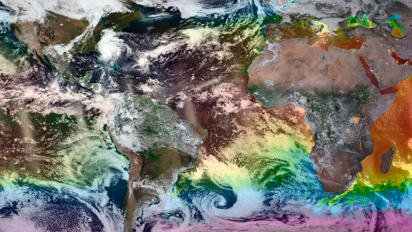
What if you could see Earth—or any part of it—as it is today? Right now? Imagine being able to choose the day or even time. Or being able to navigate views of Earth from space collected by dozens of different satellites. And with each satellite, you might flick through images acquired by one of many sensors. You could track things like wildfires or aerosols in the atmosphere. You could observe changing land cover indices, sea surface temperatures, and iceberg positions. You could even explore city lights and auroras during the night.

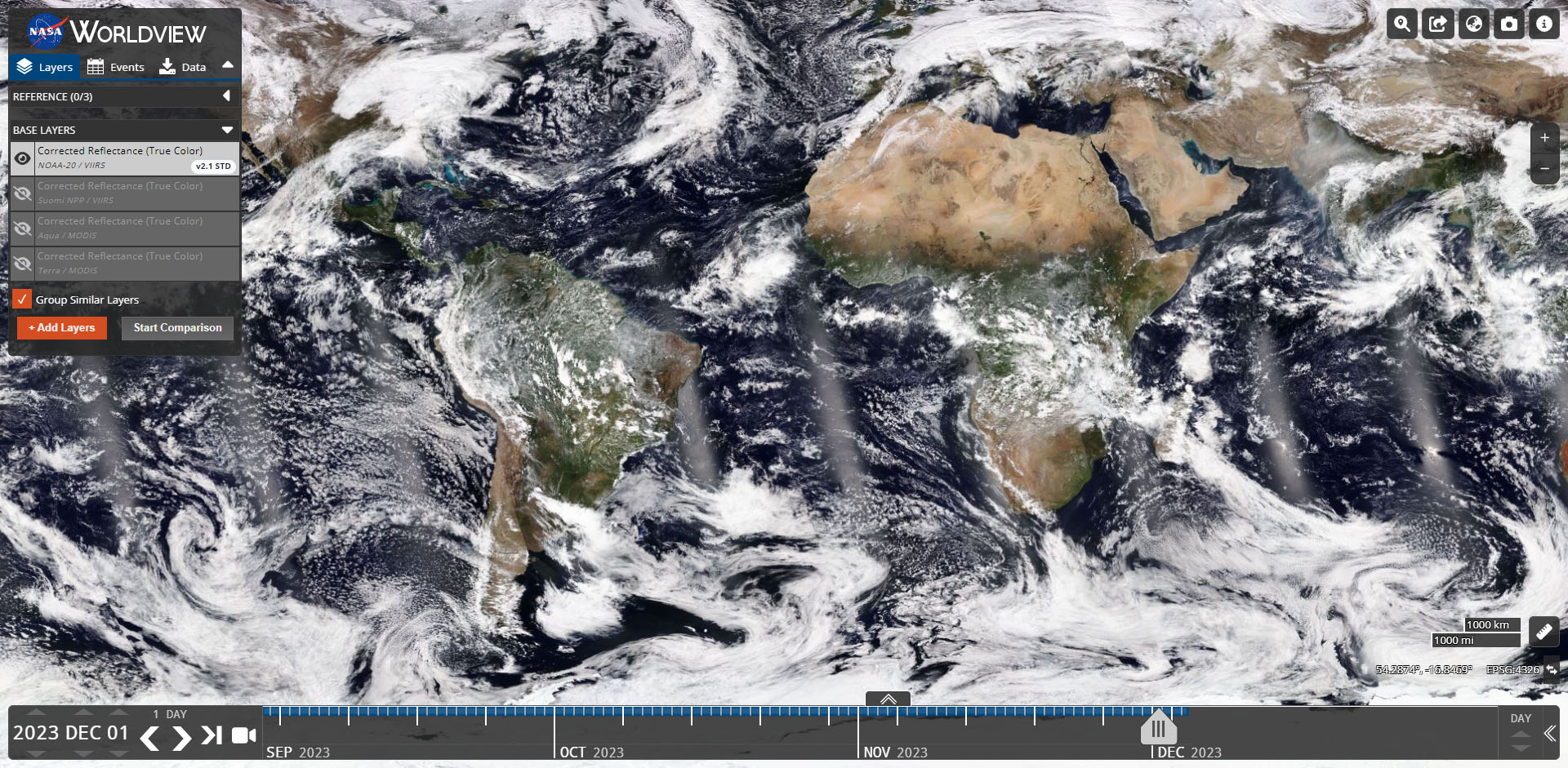
These examples—and more—only scratch the surface of how the National Aeronautics and Space Administration’s (NASA) Worldview empowers its users. Worldview provides access to global, full-resolution satellite imagery in near real-time. It allows users to browse, customize, overlay, and download a wide range of imagery in a variety of formats.

A screenshot of the Worldview interface.
Worldview is a powerful tool providing easy access to more than 20 years of data across numerous instruments and imagery products. (Source: NASA)

The imagery in Worldview is made possible by the Global Imagery Browse Services (GIBS). At present, GIBS houses more than 1,000 visualized science products. Much of the imagery is available to view within 3.5 hours of collection by satellite. Worldview and GIBS are developed and hosted by NASA’s Earth Observing System Data and Information System (EOSDIS). 

Wolrdview vir mur mosaic
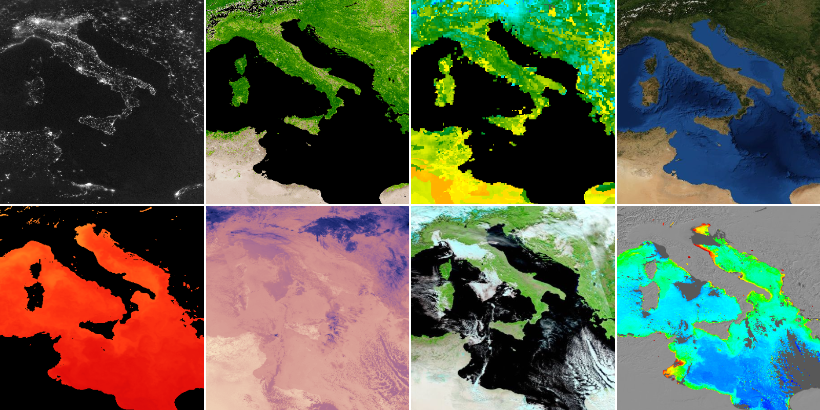
A small subset of the more than 1,000 layers in Worldview shows (top) views of Earth at nighttime, vegetation indices, daily soil moisture observations, Blue Marble basemaps, and (bottom) sea surface temperatures, infrared views of Earth, false color imagery, and chlorophyll measurements. (Source: NASA)

A single view of Earth from space is no small feat. Daily views are more impressive yet. And when those capabilities scale across hundreds of layers, opportunities and potential abound. Together, Worldview and GIBS unlock near real-time exploration of Earth at an unprecedented scale.

More to Explore

  • Be sure to check out the Worldview Image of the Week.
  • Learn how to use Worldview and browse curated stories.
  • Incorporate web map services from GIBS in your own tools and websites.

About This Map

Title
EOSDIS Worldview
Creator
NASA/EOSDIS
Tags
Imagery Interactive Interfaces NASA Satellites
Share This Article

Keep Exploring

Photo of Austrian Alps.

Back to the Map: Avalanche Risk in Dachstein Area

June 10, 2025
Behind the Map
Back to the Map Snow
Map of Detroit River in Southeast Michigan showing riverine system where ospreys have been seen in the past

Can a Bird’s-Eye View on a Map Create Empathy?

October 16, 2023
Odds & Ends
Birds Interactive
A close-up showing numerous eclipse paths over Earth.

Counting Up Eclipses

June 13, 2024
Natural Wonders
Animated Maps Historical NASA
View More Maps
Next Post
Shortwave infrared Landsat imagery showing the Grand Canyon

Unlocking Decades of Earth Imagery

April 15, 2024 Living Planet

Maps.com
Explore Today.
Create Tomorrow.
  • About Maps.com
  • Submit a Map
  • Contact
  • Legal
  • Privacy
  • Media Use
  • Manage Cookies
  • Do Not Share My Personal Information
  • Legal
  • Privacy
  • Media Use
  • Manage Cookies
  • Do Not Share My Personal Information
  • Categories
    • Living Planet
    • People & Patterns
    • Natural Wonders
    • Odds & Ends
    • Behind the Map
  • About
  • Submit Map
  • Contact Us
Subscribe

  • Legal
  • Privacy
  • Media Use
  • Manage Cookies
  • Do Not Share My Personal Information

Add New Playlist

  • Categories
    • Living Planet
    • People & Patterns
    • Natural Wonders
    • Odds & Ends
    • Behind the Map
  • About
  • Submit Map
  • Contact Us
Subscribe

  • Legal
  • Privacy
  • Media Use
  • Manage Cookies
  • Do Not Share My Personal Information

Thank you!

We have received your request and will send updates about Maps.com to your email:

Continue reading article

Sign Up For Updates

Skip to content