• Explore Categories
    • Living Planet
    • People & Patterns
    • Natural Wonders
    • Odds & Ends
    • Behind the Map
Subscribe
Search Form
No Result
View More Search Results

Can a Bird’s-Eye View on a Map Create Empathy?

by Robby Deming
October 16, 2023 Over 2 years ago
Odds & Ends

Thanks to digital mapping, we can now expect to see the world from above. Labels, landmarks, and an omniscient view provide context that helps us see where we are. But how would the world look (and feel) from that perspective without the benefit of all that context?  

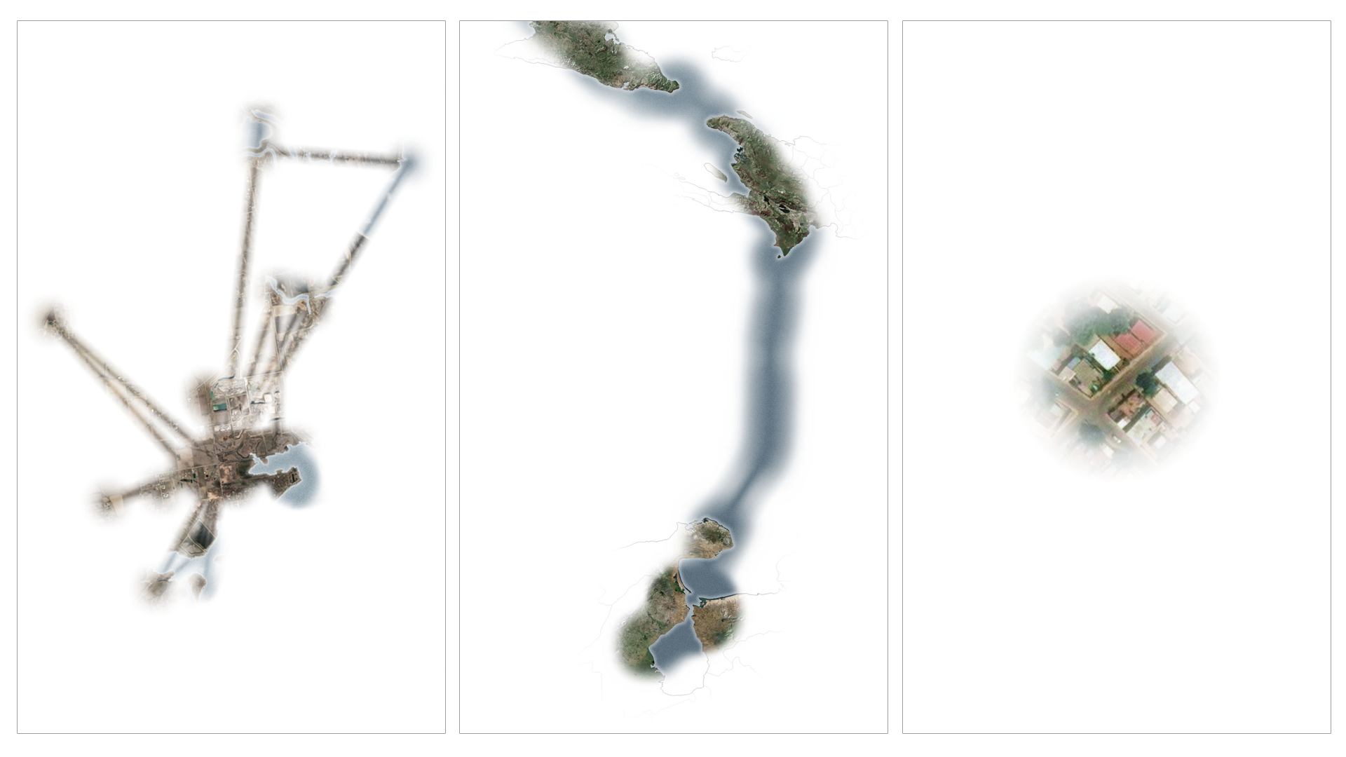
The interactive map below from John Nelson at Esri follows the journey of a young osprey named Julie. Using GPS tracking points, the map pieces together the path Julie followed from Michigan to Venezuela. But it omits the contextual signals we’re used to finding on maps, showing the world as Julie saw it.

Map of Detroit River in Southeast Michigan showing riverine system where ospreys have been seen in the past

Julie's Improbable Flight

Click below to see the interactive map from John Nelson at Esri.

Explore Interactive Map

The effect is disorienting and fascinating, all at once. We see glimpses of familiar shapes and colors as forests and shorelines zoom by. As you scroll through the map, resting where Julie rested, the world seems large and isolated. When the map scrolls the 474 miles from Cuba to Venezuela that Julie traversed in one flight, you feel that distance.

The techniques used in the map create a sense of empathy for Julie and other migrating birds like her. We feel the danger and isolation she faced on her journey and the sudden tragedy at its end. Experiencing the world the way Julie did makes us invested in her story and catalyzes a desire to save others from her fate.

Three maps showing birds-eye view over various parts of the world including Detroit and Venezuela.
Tracking Julie’s flights and limited perspective creates a zig-zag view of places throughout her journey. (Source: Esri).

By the Numbers

3,600

Number of individual location points tracked through Julie’s GPS collar.

700

Miles covered by Julie in three days of flight from Caesar Creek State Park in Ohio to Waccasassa Bay Preserve State Park in Florida.

31

Hours of nonstop flight from Isla Beata, Cuba, to Maracaibo, Venezuela.

More to Explore

  • Learn more about how the bird’s-eye view for this map was created.
  • Explore the seasonal journeys of more than 450 species with the Bird Migration Explorer from the National Audubon Society.
 

About This Map

Title
Julie’s Improbable Flight
Creator
John Nelson, Esri
Data Sources

Movebank

Tags
Birds Interactive
Share This Article

Keep Exploring

The US faces many natural disasters, the type of which varies by location.

Back to the Map: The United States of Natural Disasters

July 21, 2025
Behind the Map
Back to the Map Climate Change Disasters
Photo of Austrian Alps.

Back to the Map: Avalanche Risk in Dachstein Area

June 10, 2025
Behind the Map
Back to the Map Snow
Screenshot of ArcGIS Pro showing a work-in-progress image for Map Turtles Mapped.

Back to the Map: Map Turtles Mapped

January 16, 2025
Behind the Map
Back to the Map Conservation
View More Maps
Next Post
Map of western United States showing drought intensity from Climate Mapping for Resilience and Adaptation Portal

Which Climate Hazards Threaten Your Community?

October 16, 2023 Living Planet

Maps.com
Explore Today.
Create Tomorrow.
  • About Maps.com
  • Submit a Map
  • Contact
  • Legal
  • Privacy
  • Media Use
  • Manage Cookies
  • Do Not Share My Personal Information
  • Legal
  • Privacy
  • Media Use
  • Manage Cookies
  • Do Not Share My Personal Information
  • Categories
    • Living Planet
    • People & Patterns
    • Natural Wonders
    • Odds & Ends
    • Behind the Map
  • About
  • Submit Map
  • Contact Us
Subscribe

  • Legal
  • Privacy
  • Media Use
  • Manage Cookies
  • Do Not Share My Personal Information

Add New Playlist

  • Categories
    • Living Planet
    • People & Patterns
    • Natural Wonders
    • Odds & Ends
    • Behind the Map
  • About
  • Submit Map
  • Contact Us
Subscribe

  • Legal
  • Privacy
  • Media Use
  • Manage Cookies
  • Do Not Share My Personal Information
Julie's Improbable Flight

Thank you!

We have received your request and will send updates about Maps.com to your email:

Continue reading article

Sign Up For Updates

Skip to content