• Explore Categories
    • Living Planet
    • People & Patterns
    • Natural Wonders
    • Odds & Ends
    • Behind the Map
Subscribe
Search Form
No Result
View More Search Results

Back to the Map: Egypt Old Cairo

by Robby Deming
February 3, 2025
Behind the Map

Mai Ghaly Elgazzar’s map Egypt Old Cairo blends the past and the present to capture the rich and storied history of Cairo. For this Behind the Map, we connected with Elgazzar to learn how she sifted through 1,000 years of history to craft this map.

Maps.com: What inspired you to create this map about Cairo? How do you hope people will interact with it?

Elgazzar: The Egypt Old Cairo map was inspired by the city’s profound historical and cultural significance. My goal was to capture Old Cairo as a vibrant mosaic of religion, art, and tradition, reflecting its Islamic, Christian, and Jewish heritage. 

I was inspired by Old Cairo’s unique ability to tell a story of coexistence and cultural evolution through its landmarks. The area encapsulates centuries of history, making it a perfect subject for a map that blends cartography with storytelling.

The map is intended for tourists, history enthusiasts, and locals who wish to explore the cultural and historical richness of Old Cairo. I hope it encourages viewers to see the city not just as a geographic space but as a living narrative of art, religion, and shared heritage.

Zoomed in view of Egypt Old Cairo map
Arabic letter textures and historical images layered into the map’s frame reflect Cairo’s culture. (Source: Mai Ghaly Elgazzar)

Maps.com: How did you create this map? Were there any tools or techniques that were especially useful? 

Elgazzar: I used a combination of ArcGIS Pro for ensuring spatial accuracy of locations and leveraging its advanced cartographic tools, especially for layout design. Additionally, I utilized Adobe for ArcGIS [ArcGIS Maps for Adobe Creative Cloud] to create a vintage-style map. These tools helped me seamlessly blend the technical precision of cartography with artistic elements, incorporating historical Arabic letter textures in the background mixed with the modern text on the basemap and curated images to reflect Cairo’s cultural layers. In Adobe, I used specific tools to harmonize the look and feel of all the images, ensuring a cohesive vintage aesthetic.

Maps.com: Did anything surprise you while you were building this map? Did you run into any challenges?

Elgazzar: Whenever I create historical and cultural maps, I’m often surprised by the fascinating stories tied to the locations and the people who walked those streets in the past. This inspires me to imagine what they would have needed from a map during their time—what landmarks or indications would have been most significant to them.

For the Egypt Old Cairo map, I was particularly surprised and challenged by the numerous minarets and historical landmarks along Al-Moez Street, one of the most famous streets in Old Cairo. The sheer density of cultural and architectural treasures made it difficult to decide which landmarks to highlight, as my map couldn’t accommodate them all. This required careful selection to ensure the most important locations were represented.

Maps.com: Would you change or update this map in any way?

Elgazzar: If revisiting, I wouldn’t change the design style, as it effectively captures the vintage aesthetic and historical essence I aimed for. However, I would expand the map size to create a larger wall poster version. This would allow for a more detailed focus on specific streets, showcasing additional historical places, their images, and creating a larger gallery of these landmarks alongside the stories of the people connected to them.

Zoomed in view of Egypt Old Cairo map.
The density of landmarks on some streets meant Elgazzar had to choose which would be represented in the map. (Source: Mai Ghaly Elgazzar)

Maps.com: Where does your passion for mapmaking come from?

Elgazzar: My passion began with a deep love for storytelling through visuals. Maps have a unique ability to blend art, data, and narratives, making them powerful tools for communicating complex stories in engaging and meaningful ways. I’ve always approached mapmaking with the belief that maps are messengers of truth, which aligns with John Nelson’s quote, “Maps are messengers and tell the truth.” This belief drives me to ensure my maps convey clear, truthful messages, going beyond aesthetics to serve as meaningful and reliable representations of the events.

Maps.com: Do you have any favorite maps? Anything you’ve created or have seen elsewhere?

Elgazzar: One of my favorite maps is the Alexandria Antique Map, which I created to represent the city during the Greco-Roman period. This map beautifully illustrates Alexandria’s blend of ancient urban planning, coastal geography, and its deep connection to Alexander Al-Makdony, who founded the city as a symbol of knowledge and trade.

The second map I cherish is the one depicting the journey of Prophet Moses with the Children of Israel during their years of wandering. This map is designed in Arabic, using Arabic calligraphy to add a cultural and religious depth to the story. It traces the path through deserts and various lands, offering a visual representation of the spiritual and physical journey of the Israelites. The combination of historical, religious, and geographical elements in the map enhances its storytelling power.

Maps.com: Do you have anything in mind for future mapping projects?

Elgazzar: One of my future mapping projects involves delving deep into the David Rumsey library to explore more historical maps. By studying ancient routes and the movements of historical peoples, I aim to find inspiration for creating modern maps that reflect these ancient journeys, connecting the past with the present in a visually meaningful way.

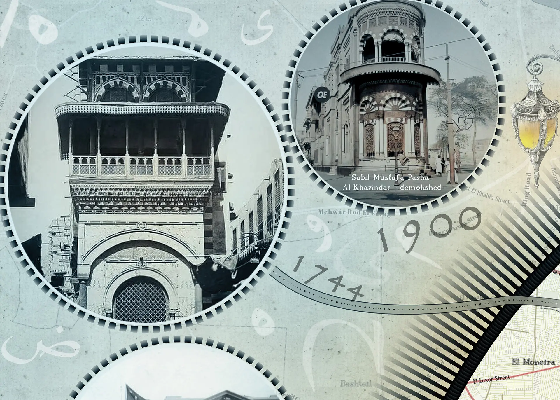
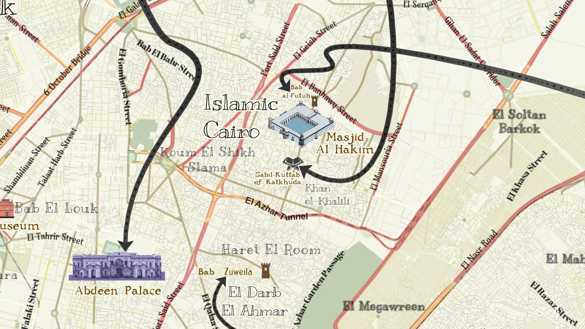
Featured Contributors

Mai Ghaly Elgazzar

Mai Ghaly Elgazzar

Mai Ghaly Elgazzar is a cartographer who is passionate about GIS, graphic and video creation, and specializing in data visualization. Over the years, she’s earned several awards from Esri, the Wisconsin Land Information Association (WLIA), and the GIS Certification Institute (GISCI) for her work. She enjoys combining creativity and technology to bring data to life in meaningful ways.

Tags
Back to the Map Historical
Share This Article

Keep Exploring

The US faces many natural disasters, the type of which varies by location.

Back to the Map: The United States of Natural Disasters

July 21, 2025
Behind the Map
Back to the Map Climate Change Disasters
Photo of Austrian Alps.

Back to the Map: Avalanche Risk in Dachstein Area

June 10, 2025
Behind the Map
Back to the Map Snow
Screenshot of ArcGIS Pro showing a work-in-progress image for Map Turtles Mapped.

Back to the Map: Map Turtles Mapped

January 16, 2025
Behind the Map
Back to the Map Conservation
View More Maps
Next Post
Map showing location and density of forested freshwater wetlands in the US.

How Are Wetlands Trending in the US?

February 3, 2025 Living Planet

Maps.com
Explore Today.
Create Tomorrow.
  • About Maps.com
  • Submit a Map
  • Contact
  • Legal
  • Privacy
  • Media Use
  • Manage Cookies
  • Do Not Share My Personal Information
  • Legal
  • Privacy
  • Media Use
  • Manage Cookies
  • Do Not Share My Personal Information
  • Categories
    • Living Planet
    • People & Patterns
    • Natural Wonders
    • Odds & Ends
    • Behind the Map
  • About
  • Submit Map
  • Contact Us
Subscribe

  • Legal
  • Privacy
  • Media Use
  • Manage Cookies
  • Do Not Share My Personal Information

Add New Playlist

  • Categories
    • Living Planet
    • People & Patterns
    • Natural Wonders
    • Odds & Ends
    • Behind the Map
  • About
  • Submit Map
  • Contact Us
Subscribe

  • Legal
  • Privacy
  • Media Use
  • Manage Cookies
  • Do Not Share My Personal Information

Thank you!

We have received your request and will send updates about Maps.com to your email:

Continue reading article

Sign Up For Updates

Skip to content