• Explore Categories
    • Living Planet
    • People & Patterns
    • Natural Wonders
    • Odds & Ends
    • Behind the Map
Subscribe
Search Form
No Result
View More Search Results

Where Are Agricultural Workers Threatened by Extreme Heat?

by Robby Deming
November 2, 2023 Over 2 years ago
Living Planet

When you think of a changing climate’s impact on our food, what comes to mind? Some may point to declining yields of important crops. Or the fact that crop suitability will look very different in the future. But what about the people who cultivate these crops and the conditions they’ll face?

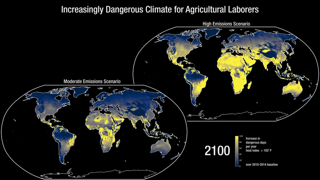
The animated map from the National Aeronautics and Space Administration’s (NASA) Scientific Visualization Studio provides context. It forecasts increases in dangerous heat days that could impact agricultural workers.

Two maps showing projected increases in dangerous heat days by 2100 under two different climate scenarios.
The map shows increases in dangerous heat days in both scenarios but are far more pronounced in the high-emissions scenario. (Source: NASA’s Scientific Visualization Studio)

The map models extreme heat through 2100 under a moderate- and high-emissions scenario. In both scenarios, parts of South America, Africa, and Asia see significant increases in extreme heat days. North America, Europe, and Australia would also see dramatic impacts under a high-emissions scenario.

This comparison helps us better understand the risks of climate change. We can see how curbing emissions can reduce impacts and the perils we face if we don’t.  

Unfortunately, many of the places expected to see the highest increases already suffer from extreme heat. The 2010–2014 baseline shows people in South America, Africa, and Asia are already vulnerable.

The interconnected nature of our food system means local threats have global impacts. Food production will be challenging with warmer temperatures. But we must account for the people who farm and harvest our food. The world depends on them.

More to Explore

  • Check out an alternative version of the map with callouts for five locations across the US.

About This Map

Title
Increasingly Dangerous Climate for Agricultural Workers
Creator
NASA Scientific Visualization Studio
Data Sources

Multiple climate scenarios

Tags
Agriculture Animated Maps Extreme Heat
Share This Article

Keep Exploring

Article heat dot gov embed preview

Where Is Heat Becoming More Extreme in the US?

April 8, 2024
Living Planet
Climate Change Extreme Heat Resilience
Map of the US showing amount and share of crop sales and animal product sales by county.

Agriculture in America

September 12, 2024
People & Patterns
Agriculture Economy Interactive
Map showing heat exposure and redlining in Richmond, VA.

Where Has Historical Redlining Worsened Heat Exposure?

September 23, 2024
People & Patterns
Demographics Equity Extreme Heat
View More Maps
Next Post
Map of the US by county showing fair market rents in 2023.

Where Is Rent Most Expensive in the US?

November 2, 2023 People & Patterns

Maps.com
Explore Today.
Create Tomorrow.
  • About Maps.com
  • Submit a Map
  • Contact
  • Legal
  • Privacy
  • Media Use
  • Manage Cookies
  • Do Not Share My Personal Information
  • Legal
  • Privacy
  • Media Use
  • Manage Cookies
  • Do Not Share My Personal Information
  • Categories
    • Living Planet
    • People & Patterns
    • Natural Wonders
    • Odds & Ends
    • Behind the Map
  • About
  • Submit Map
  • Contact Us
Subscribe

  • Legal
  • Privacy
  • Media Use
  • Manage Cookies
  • Do Not Share My Personal Information

Add New Playlist

  • Categories
    • Living Planet
    • People & Patterns
    • Natural Wonders
    • Odds & Ends
    • Behind the Map
  • About
  • Submit Map
  • Contact Us
Subscribe

  • Legal
  • Privacy
  • Media Use
  • Manage Cookies
  • Do Not Share My Personal Information

Thank you!

We have received your request and will send updates about Maps.com to your email:

Continue reading article

Sign Up For Updates

Skip to content