• Explore Categories
    • Living Planet
    • People & Patterns
    • Natural Wonders
    • Odds & Ends
    • Behind the Map
Subscribe
Search Form
No Result
View More Search Results

Where There’s Smoke

by Joshua Stevens
March 18, 2024
Living Planet
Portion of a smoke forecast map produced by NOAA, which shows increased levels of smoke across the contiguous US on September 1, 2021.

(Source: NOAA)

Wildfires in the United States make headlines each summer. This is especially true in California and the Pacific Northwest. And the fires are larger, burn more intensely, and happen more frequently than in decades past. People cause most wildfires in the U.S., though climate change is making the fires worse and more likely to happen.

Small, low-intensity wildfires can be beneficial. But fires that grow out of control pose significant threats to humans, property, and ecosystems. These fires can burn tens of thousands to millions of acres. And the smoke they produce can affect air quality on the opposite side of the country.

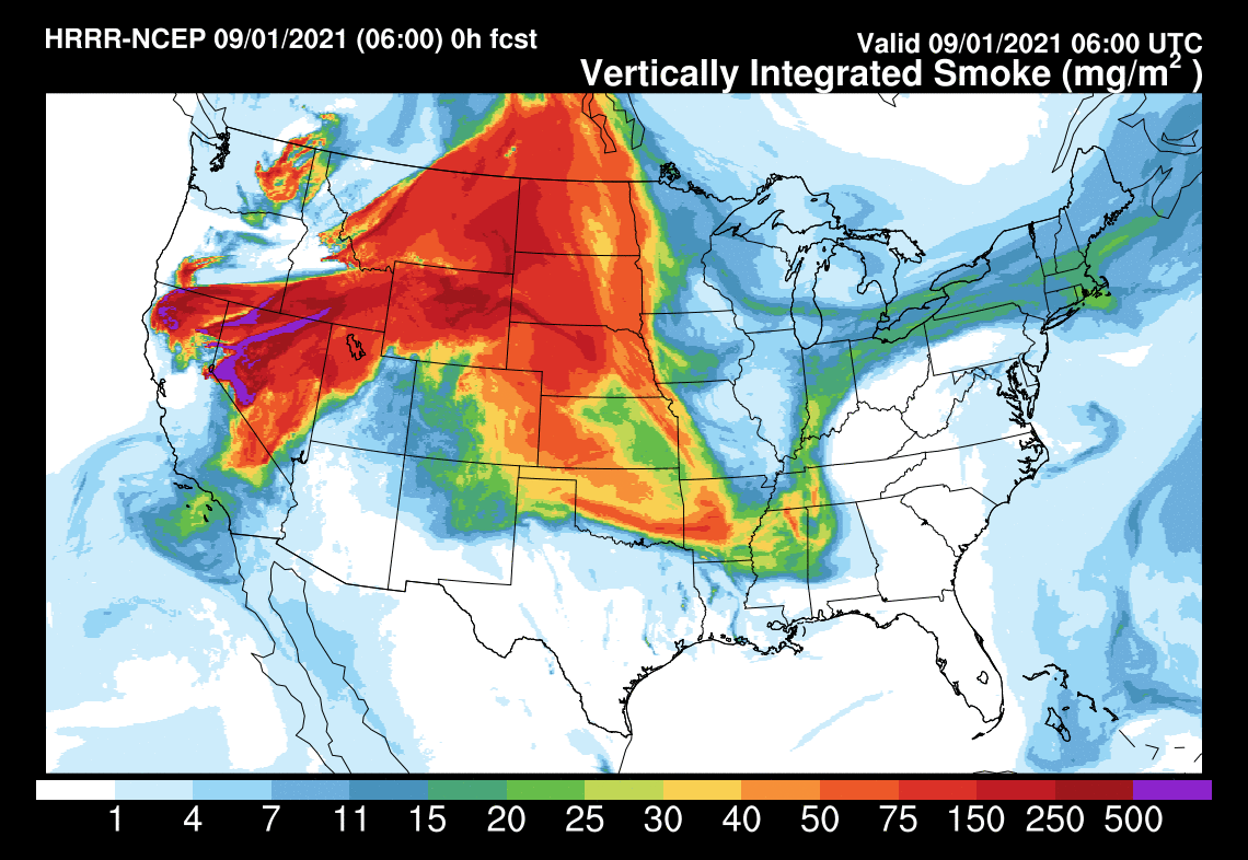
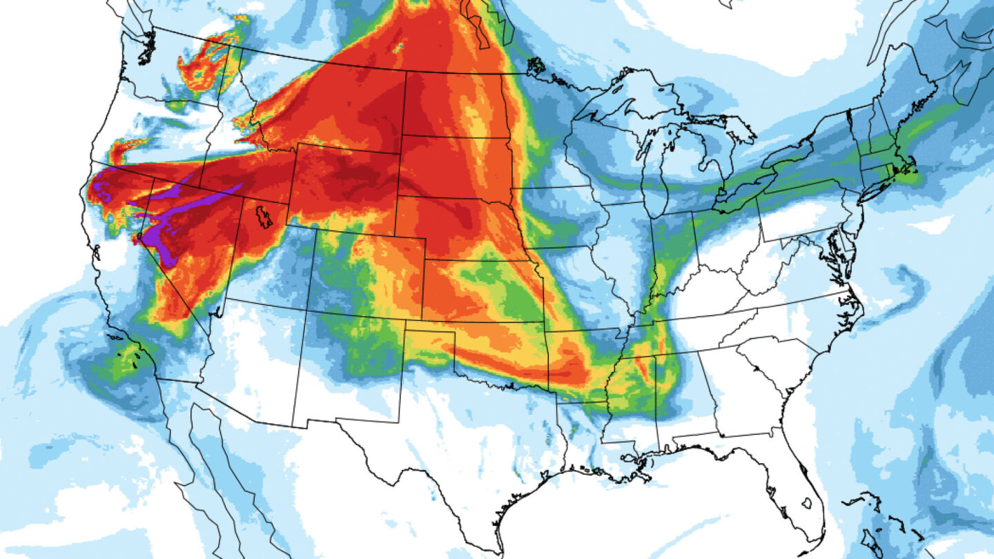
Maps combining satellite and weather data can help us understand and communicate smoke transport. The National Oceanic and Atmospheric Administration (NOAA) developed the High-Resolution Rapid Refresh Smoke (HRRR-Smoke) model to do just that.

Portion of a smoke forecast map produced by NOAA, which shows increased levels of smoke across the contiguous US on September 1, 2021.
Vertically integrated smoke from the HRRR model is an estimate of smoke mass. It considers all the smoke in a vertical column from the surface to about 15.5 miles (25 kilometers) into the atmosphere. (Source: NOAA)

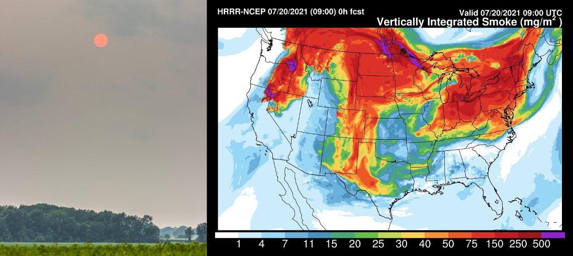
Smoke forecasts are valuable because wildfires can burn for several weeks, and the smoke can remain in the atmosphere for much longer. During the summer of 2021, smoke from wildfires in the US West Coast left a smoky pall over much of the country. Although most of the smoke came from California, Oregon, and Washington, the smoke and its effects reached the East Coast. People all over the country shared photos of smoke-tinged sunsets. (Smoke particles in the atmosphere scatter sunlight and make the Sun appear red.)

The Sun appears red due to wildfire smoke scattering light high in the atmosphere in Dansville, MI. An adjacent map shows smoke conditions on the same day and time.
The Sun appears red in Dansville, Michigan, on July 20, 2021, due to smoke from fires near the West Coast. The HRRR-Smoke map on the right depicts conditions on the same day. (Source: Joshua Stevens and NOAA)

NOAA’s HRRR-Smoke model and maps have a scientific purpose. But that does not limit their utility to a general audience. An intuitive and largely colorblind-friendly color scheme keeps the maps clear and concise. Raw model output data is also available for download and use by the public.

About This Map

Title
HRRR-Smoke model
Creator
NOAA/Global Systems Laboratory
Tags
Health Interactive Smoke Wildfires
Share This Article

Keep Exploring

Smoke from wildfires in central Canada has made its way across the eastern United States.

Canadian Smoke in US Skies

June 9, 2025
Living Planet
Air Quality Animated Maps Health
Map of Canada showing active wildfires in 2023.

How Widespread Was Canada’s Historic 2023 Wildfire Season?

December 11, 2023
Living Planet
Animated Maps Submitted Map Wildfires
Article air quality aware featured nr

What’s the Status of Air Quality across the US?

August 22, 2024
Living Planet
Demographics Interactive Smoke
View More Maps
Next Post
Map of Eastern US showing states and counties where spotted lanterfly infestations have been confirmed.

Where Is the Spotted Lanternfly Spreading across the US?

March 18, 2024 Living Planet

Maps.com
Explore Today.
Create Tomorrow.
  • About Maps.com
  • Submit a Map
  • Contact
  • Legal
  • Privacy
  • Media Use
  • Manage Cookies
  • Do Not Share My Personal Information
  • Legal
  • Privacy
  • Media Use
  • Manage Cookies
  • Do Not Share My Personal Information
  • Categories
    • Living Planet
    • People & Patterns
    • Natural Wonders
    • Odds & Ends
    • Behind the Map
  • About
  • Submit Map
  • Contact Us
Subscribe

  • Legal
  • Privacy
  • Media Use
  • Manage Cookies
  • Do Not Share My Personal Information

Add New Playlist

  • Categories
    • Living Planet
    • People & Patterns
    • Natural Wonders
    • Odds & Ends
    • Behind the Map
  • About
  • Submit Map
  • Contact Us
Subscribe

  • Legal
  • Privacy
  • Media Use
  • Manage Cookies
  • Do Not Share My Personal Information

Thank you!

We have received your request and will send updates about Maps.com to your email:

Continue reading article

Sign Up For Updates

Skip to content