Nestled in the Andes Mountains and transected by the Chama River, Mérida is one of 23 states in Venezuela. It is home to the city and state capital, also named Mérida (officially Santiago de los Caballeros de Mérida). Founded in 1558, the city of Mérida has a rich history and vibrant architecture. This background, paired with its stunning natural environment and modern transportation system, makes Mérida a popular tourist destination. It also features the highest and longest cable car in the world.
While unique in many ways, Mérida has one thing in common with numerous other places on Earth: Its landscape and people are subject to a climate undergoing continuous change.
Rayner Castro, a geographic information system (GIS) analyst and cartographer, captures key details of the terrain and climate of the state of Mérida in this elegant set of maps.
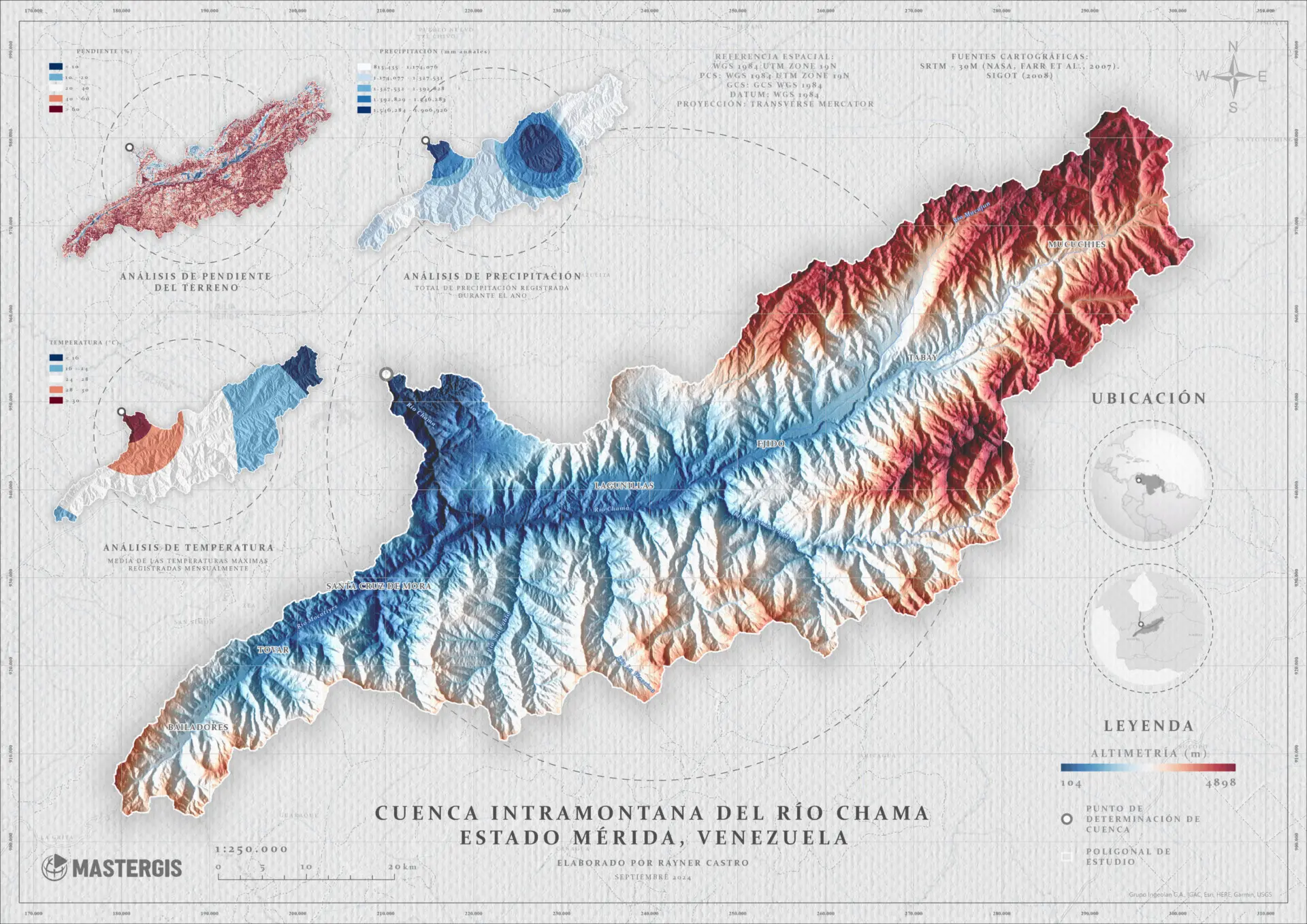
Annotated in Spanish, the primary map depicts the topography of the state of Mérida. Valleys and low elevations (around 100 meters, or 328 feet, above sea level) are shown in blue. Higher elevations are shown in white, with the highest peaks (around 4,900 meters, or 16,076 feet, above sea level) in red. The map uses shaded relief to cast shadows across the landscape, giving the topography a realistic appearance. (Since the shadows are drawn to the northwestern slopes, you might experience relief inversion. Shadows in shaded relief are typically drawn to the southeast to combat this effect.)
The other maps in the graphic depict the slope, or steepness, of the terrain (top left), total precipitation during the year (top right), and the average monthly maximum temperature (bottom left). Annual rainfall in some areas, particularly near the city of Mérida, can approach 1,900 mm (75 inches) over the year. Monthly temperatures range from 16°C (60°F) to 30°C (86°F). As with precipitation, the city of Mérida also experiences the highest temperatures.
Castro’s infographic is based on several datasets. These include elevation data from the Shuttle Radar Topography Mission (SRTM) and precipitation and temperature data from the Information System for Territorial Management and Planning (SIGOT).
About This Map
- Title
- Intramontane basin of the Chama River, Mérida State, Venezuela
- Creator
- Rayner Castro
- Data Sources
-
- Shuttle Radar Topographic Mission
- Information System for Territorial Management and Planning
This map was contributed through the Maps.com submission program. If you’d like your map to be featured, submit it for consideration.
- Tags